
Tee lahjoitus
Topografinen kartta Bena
Napsauta karttaa nähdäksesi korkeus.
Tee lahjoitus
Tietoja tästä kartasta
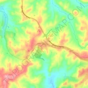
Nimi: Topografinen kartta Bena, korkeus, helpotus.
Paikka: Bena, Shire of South Gippsland, Victoria, 3946, Australia (-38.43075 145.74144 -38.39075 145.78144)
Keskimääräinen korkeus: 187 m
Minimi korkeus: 123 m
Maksimi korkeus: 256 m
Tee lahjoitus
Muut topografiset kartat
Napsauta karttaa nähdäksesi sen topografian, sen korkeus ja sen helpotuksen.
City of Melbourne
Melbourne's topography is characterized by a diverse landscape that transitions from flat coastal plains to rolling hills and mountainous regions. The city is situated at the northern end of Port Phillip Bay, where the terrain is predominantly flat, facilitating urban development. As one moves eastward, the…
Keskimääräinen korkeus: 18 m
Melbourne
Melbourne is also prone to isolated convective showers forming when a cold pool crosses the state, especially if there is considerable daytime heating. These showers are often heavy and can include hail, squalls, and significant drops in temperature, but they often pass through very quickly with a rapid…
Keskimääräinen korkeus: 185 m
Grampians National Park
Mount William is known within the gliding community for the "Grampians Wave", a weather phenomenon that sometimes enables glider pilots to reach extreme altitudes of the order of 28,000 ft (8,500 m). This predominantly occurs during the months of May, June, September and October when strong westerly winds flow…
Keskimääräinen korkeus: 262 m
Tee lahjoitus
Trentham
Trentham is a small town in the Shire of Hepburn and Shire of Moorabool local government area, Victoria, Australia. At the 2016 census, Trentham had a population of 1,180, with a median age of 55 years. Located at an altitude of 700 metres (2,297 ft), the town is 87 kilometres (54 mi) north-west of Melbourne.
Keskimääräinen korkeus: 702 m
Tee lahjoitus
Tee lahjoitus
Albert Park
Heritage Victoria notes that Albert Park's St Vincent Gardens "is historically important as the premier 'square' development in Victoria based on similar models in London. It is significant as the largest development of its type in Victoria and for its unusual development as gardens rather than the more usual…
Keskimääräinen korkeus: 6 m
Tee lahjoitus
Tee lahjoitus
Beaufort
Beaufort has an elevation-influenced oceanic climate (Köppen: Cfb), with tepid, relatively dry summers and cool, wetter winters. Average maxima vary from 25.3 °C (77.5 °F) in January to 10.1 °C (50.2 °F) in July, while average minima fluctuate between 11.5 °C (52.7 °F) in February and 3.2 °C (37.8 °F)…
Keskimääräinen korkeus: 390 m
Yarra Ranges National Park
Australia > Victoria > Lake Mountain Alpine Resort
Keskimääräinen korkeus: 465 m
Tee lahjoitus
Tee lahjoitus
Tee lahjoitus
Tee lahjoitus
Hamilton
Like most of south-western Victoria, Hamilton has a temperate mediterranean climate (Csb). Cold fronts regularly sweep in from the Southern Ocean. Although daytime temperatures occasionally reach into the 30s even 40s during summer, daytime temperatures in the mid teens will often linger into December and are…
Keskimääräinen korkeus: 196 m
Tee lahjoitus
Tee lahjoitus
Tee lahjoitus
Tee lahjoitus
Tee lahjoitus
Tee lahjoitus
Tee lahjoitus
Frankston
Australia > Victoria > Melbourne
Olivers Hill is the most prominent elevation in Frankston which rises to 55 metres above sea level (180 feet) at its highest point in the suburb. Its origins date to approximately 415 to 360 million years ago. Its base is Mount Eliza Granite dating from the Devonian period, which was covered in lava tuffs in…
Keskimääräinen korkeus: 40 m
Tee lahjoitus
Tee lahjoitus
Tee lahjoitus
Tee lahjoitus
Tee lahjoitus
Tee lahjoitus
Tee lahjoitus
Tee lahjoitus
Tee lahjoitus