
Tee lahjoitus
Topografinen kartta Marble Hill
Napsauta karttaa nähdäksesi korkeus.
Tee lahjoitus
Tietoja tästä kartasta
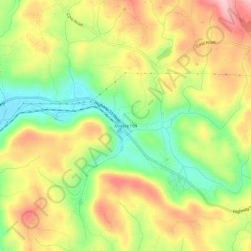
Nimi: Topografinen kartta Marble Hill, korkeus, helpotus.
Paikka: Marble Hill, Pickens County, Georgia, 30177, United States (34.41069 -84.35688 34.45069 -84.31688)
Keskimääräinen korkeus: 404 m
Minimi korkeus: 307 m
Maksimi korkeus: 502 m
Tee lahjoitus
Muut topografiset kartat
Napsauta karttaa nähdäksesi sen topografian, sen korkeus ja sen helpotuksen.
Jasper
United States > Georgia > Pickens County
Jasper was founded in 1853 as seat of the newly formed Pickens County. It was incorporated in 1857 as a town and in 1957 as a city. The community is named for William Jasper, a hero of the American Revolutionary War. Jasper is situated at an elevation of 1,463 feet (446 m).
Keskimääräinen korkeus: 408 m
Tee lahjoitus