
Tee lahjoitus
Topografinen kartta Cisco
Napsauta karttaa nähdäksesi korkeus.
Tee lahjoitus
Tietoja tästä kartasta
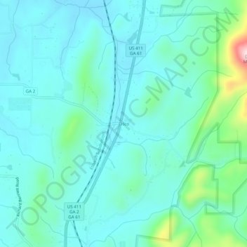
Nimi: Topografinen kartta Cisco, korkeus, helpotus.
Paikka: Cisco, Murray County, Georgia, 30708, United States (34.93119 -84.75633 34.97119 -84.71633)
Keskimääräinen korkeus: 293 m
Minimi korkeus: 236 m
Maksimi korkeus: 565 m
Tee lahjoitus
Muut topografiset kartat
Napsauta karttaa nähdäksesi sen topografian, sen korkeus ja sen helpotuksen.
Chatsworth
United States > Georgia > Murray County
Chatsworth is located in central Murray County at 34°46′20″N 84°46′44″W / 34.77222°N 84.77889°W / 34.77222; -84.77889 (34.772336, -84.778977), in northwestern Georgia. It sits at an elevation of 750 feet (230 m) on the west side of the valley of Holly Creek, with 2,840-foot (870 m) Fort…
Keskimääräinen korkeus: 241 m