
Kiitos, että tuet tätä sivustoa ❤️
Tee lahjoitus
Tee lahjoitus
Topografinen kartta Matt
Napsauta karttaa nähdäksesi korkeus.
Kiitos, että tuet tätä sivustoa ❤️
Tee lahjoitus
Tee lahjoitus
Tietoja tästä kartasta
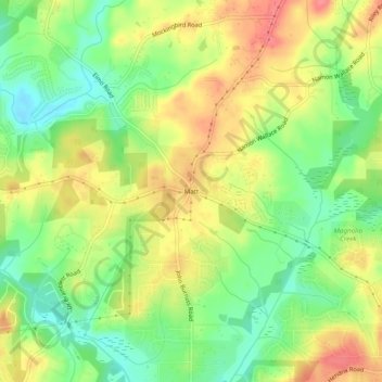
Nimi: Topografinen kartta Matt, korkeus, helpotus.
Paikka: Matt, Forsyth County, Georgia, 30028, United States (34.27871 -84.17297 34.31871 -84.13297)
Keskimääräinen korkeus: 353 m
Minimi korkeus: 319 m
Maksimi korkeus: 388 m
Kiitos, että tuet tätä sivustoa ❤️
Tee lahjoitus
Tee lahjoitus
Muut topografiset kartat
Napsauta karttaa nähdäksesi sen topografian, sen korkeus ja sen helpotuksen.
Lake Lanier
United States > Georgia > Forsyth County > Cumming
According to the Army Corps of Engineers, the Dam has a current installed capacity of 126 megawatts and a hydraulic head of 136 feet. Other pertinent information on the reservoir, power plant, etc. can be found on the Mobile District Corps of Engineers web site.[12][13] Also, historic operational information…
Keskimääräinen korkeus: 351 m
Kiitos, että tuet tätä sivustoa ❤️
Tee lahjoitus
Tee lahjoitus