
Tee lahjoitus
Topografinen kartta Ash
Napsauta karttaa nähdäksesi korkeus.
Tee lahjoitus
Tietoja tästä kartasta
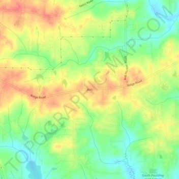
Nimi: Topografinen kartta Ash, korkeus, helpotus.
Paikka: Ash, Paulding County, Georgia, 30140, United States (33.78372 -84.87022 33.82372 -84.83022)
Keskimääräinen korkeus: 319 m
Minimi korkeus: 290 m
Maksimi korkeus: 347 m
Tee lahjoitus
Muut topografiset kartat
Napsauta karttaa nähdäksesi sen topografian, sen korkeus ja sen helpotuksen.
Dallas
United States > Georgia > Paulding County
On April 4, 1977, near the site marker for the Battle of New Hope Church, the forced landing of Southern Airways Flight 242 occurred. The passenger jetliner, a McDonnell Douglas DC-9 with 81 passengers and 4 crew members, was flying from Northwest Alabama Regional Airport to Atlanta Municipal Airport. Upon…
Keskimääräinen korkeus: 307 m
Tee lahjoitus
Dallas
United States > Georgia > Paulding County
On April 4, 1977, near the site marker for the Battle of New Hope Church, the forced landing of Southern Airways Flight 242 occurred. The passenger jetliner, a McDonnell Douglas DC-9 with 81 passengers and 4 crew members, was flying from Northwest Alabama Regional Airport to Atlanta Municipal Airport. Upon…
Keskimääräinen korkeus: 307 m