
Tee lahjoitus
Topografinen kartta Argonne Forest
Napsauta karttaa nähdäksesi korkeus.
Tee lahjoitus
Tietoja tästä kartasta
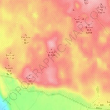
Nimi: Topografinen kartta Argonne Forest, korkeus, helpotus.
Paikka: Argonne Forest, Pierce County, Washington, United States (47.04782 -122.65490 47.04792 -122.65480)
Keskimääräinen korkeus: 110 m
Minimi korkeus: 13 m
Maksimi korkeus: 149 m
Tee lahjoitus
Muut topografiset kartat
Napsauta karttaa nähdäksesi sen topografian, sen korkeus ja sen helpotuksen.
Riverside State Park
United States > Washington > Spokane County > Spokane
Terrain in park is varied, with steep valleys along the rivers and more flat plateaus above. The Spokane River falls from approximately 1,680 feet when it enters the park in the south to approximately 1,540 feet at the Long Lake Reservoir on the northern edge of the park. Surrounding plateaus rise to 2,200…
Keskimääräinen korkeus: 645 m
Walla Walla
United States > Washington > Walla Walla County
Walla Walla County features a varied topography characterized by rolling hills, valleys, and river systems. The elevation in the area averages around 940 feet (approximately 287 meters) above sea level, with some areas rising to nearly 1,200 feet. The landscape is shaped by the Walla Walla River, which carves…
Keskimääräinen korkeus: 297 m
Tee lahjoitus
Tee lahjoitus
Tee lahjoitus
Tee lahjoitus
Tee lahjoitus
Colchuck Lake
United States > Washington > Chelan County
Colchuck Lake has an area of approximately 87.8 acres (0.355 km2) and a maximum surface elevation of 5,570 feet above sea level, depending on the fluctuation of the depth of the lake. The lake has a tributary basin of 941 acres (3.81 km2) acres, and an average storage capacity estimated at 1,570 acre-feet.
Keskimääräinen korkeus: 1 886 m
Lake Chelan
United States > Washington > Chelan County > Chelan
Lake Chelan (/ʃəˈlæn/ shə-LAN) is a narrow, 50.5 mi (81.3 km) long lake in Chelan County, north-central Washington state, U.S. It is an overdeepened lake and resembles a fjord, with an average width of 1.3 mi (2.1 km). Near its upper end, the lake surface lies more than 6,600 ft (2,000 m) below peaks less…
Keskimääräinen korkeus: 1 358 m
Tee lahjoitus
Bainbridge Island
United States > Washington > Kitsap County > Bainbridge Island
Keskimääräinen korkeus: 29 m
Tee lahjoitus
Bell Hill
United States > Washington > Clallam County > Bell Hill
Bell Hill is located in eastern Clallam County and is bordered to the north by the city of Sequim. The community is named for the hill that it sits on, which rises to an elevation of over 1,000 feet (300 m) above sea level, or more than 800 feet (240 m) above the center of Sequim. Bell Hill actually has two…
Keskimääräinen korkeus: 139 m
Wenatchee Confluence State Park
United States > Washington > Chelan County > Sunnyslope
Keskimääräinen korkeus: 208 m
Tee lahjoitus
Millwood
United States > Washington > Spokane County
The topography of the city is mostly flat as it lies on the floor of the Spokane Valley, though it does slope gently down towards the north. The northern edge of town is defined by the Spokane River, where the terrain promptly drops about 20 feet down to the river bank.
Keskimääräinen korkeus: 600 m
Tee lahjoitus
Tee lahjoitus
Tee lahjoitus
Washtucna
United States > Washington > Adams County
It sits at the head of Washtucna Coulee, a thin but deep valley that runs west to Connell, Washington where it merges with Providence Coulee to form Esquatzel Coulee. Being located on the floor of the coulee, Washtucna is at relatively lower elevation than the terrain that surrounds it. The floor of the coulee…
Keskimääräinen korkeus: 351 m
Tee lahjoitus
Tee lahjoitus
Tee lahjoitus
Fritz Hedges Waterway Park
United States > Washington > King County > Seattle
Keskimääräinen korkeus: 32 m
Tee lahjoitus
Tee lahjoitus
Chehalis Village
United States > Washington > Grays Harbor County > Chehalis Village
Keskimääräinen korkeus: 42 m
Tee lahjoitus
Tee lahjoitus
Desert Aire
United States > Washington > Grant County
Desert Aire is a census-designated place (CDP) in Grant County, Washington, United States. Desert Aire's elevation is 560 ft (170 m). The population was 1,626 at the 2010 census, up from 1,124 at the 2000 census.
Keskimääräinen korkeus: 177 m
Tee lahjoitus
Tekoa
United States > Washington > Whitman County
Tekoa was incorporated in 1889 with just under 300 people at the base of Tekoa Mountain (elevation 2,490 feet), on the extreme eastern end of the Palouse, and to the west of the Benewah Range of Idaho. In 1908 the railroad trestle above the town was built. By 1910 the population had grown to 1,694. Over the…
Keskimääräinen korkeus: 792 m
Tee lahjoitus
Waterfront Park
United States > Washington > Clark County > Vancouver
A 12-foot (3.7 m) stone and bronze structure called Headwaters (or sometimes the Headwaters Wall) designed by artist Larry Kirkland was installed at Waterfront Park in August 2019. It is an interactive water feature that cost $3.5 million to construct. Headwaters features a cast bronze bas relief map of the…
Keskimääräinen korkeus: 13 m
Tee lahjoitus
Lake Marcel
United States > Washington > King County
Lake Marcel is at an altitude of 295 feet (90 m) above sea level. The lake sits in a bowl at the top of Stillwater Hill on the east side of the Snoqualmie Valley, north of Carnation. It has two main areas of water connected by a channel, and several peninsular features make an extensive shoreline around the…
Keskimääräinen korkeus: 110 m
Tee lahjoitus
Manitou Beach Park
United States > Washington > Kitsap County > Bainbridge Island
Keskimääräinen korkeus: 27 m
Ebey's Landing National Historical Reserve
United States > Washington > Island County
Keskimääräinen korkeus: 25 m
Tee lahjoitus
Asotin
United States > Washington > Asotin County
Asotin is located south of Clarkston, on the west bank of the Snake River. The elevation is 801 feet (244 m) above sea level.
Keskimääräinen korkeus: 319 m
Mount Skokomish Wilderness
United States > Washington > Mason County
Mount Skokomish Wilderness is located in the southeast corner of Olympic National Forest, just north of Lake Cushman. It consists of two long rocky ridges running roughly northeast to southwest. Elevations range from about 2,000 feet (609.6 m) to 6,434 feet (1,961.1 m) at the peak of Mount Skokomish on the…
Keskimääräinen korkeus: 1 058 m
Tee lahjoitus
Tee lahjoitus