
Tee lahjoitus
Topografinen kartta Rathfriland
Napsauta karttaa nähdäksesi korkeus.
Tee lahjoitus
Tietoja tästä kartasta
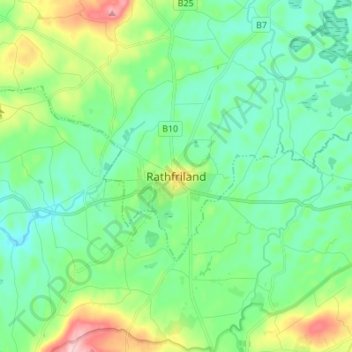
Nimi: Topografinen kartta Rathfriland, korkeus, helpotus.
Keskimääräinen korkeus: 106 m
Minimi korkeus: 59 m
Maksimi korkeus: 240 m
Tee lahjoitus
Muut topografiset kartat
Napsauta karttaa nähdäksesi sen topografian, sen korkeus ja sen helpotuksen.
County Antrim
United Kingdom > Northern Ireland
A large portion of Antrim is hilly, especially in the east, where the highest elevations are attained. The range runs north and south, and, following this direction, the highest points are Knocklayd 514 m (1,690 ft), Slieveanorra 508 m (1,670 ft), Trostan 550 m (1,800 ft), Slemish 437 m (1,430 ft), Agnew's…
Keskimääräinen korkeus: 70 m
Tee lahjoitus
Tee lahjoitus
Tee lahjoitus
Tee lahjoitus
Magheraconluce
United Kingdom > Northern Ireland > County Down > Annahilt
Keskimääräinen korkeus: 112 m
Tee lahjoitus
Tee lahjoitus
Tee lahjoitus
Tee lahjoitus
Tee lahjoitus
Tee lahjoitus
Tee lahjoitus
Tee lahjoitus
Tee lahjoitus
Tee lahjoitus
Tee lahjoitus
Tee lahjoitus
Tee lahjoitus
Tee lahjoitus
Tee lahjoitus
Tee lahjoitus
Botanic Gardens
United Kingdom > Northern Ireland > County Antrim > Belfast
Keskimääräinen korkeus: 15 m
Tee lahjoitus
Tee lahjoitus
Rathlin Island
United Kingdom > Northern Ireland > County Antrim > Church Bay
Keskimääräinen korkeus: 10 m
Tee lahjoitus
Castlecaufield
United Kingdom > Northern Ireland > County Tyrone > Castlecaulfield
Keskimääräinen korkeus: 95 m
Tee lahjoitus
Loughgiel Millennium Centre
United Kingdom > Northern Ireland > County Antrim > Loughguile
Keskimääräinen korkeus: 155 m
Lower Lough Erne
United Kingdom > Northern Ireland > Enniskillen > Lisnarrick
Keskimääräinen korkeus: 96 m
Drumahoe
United Kingdom > Northern Ireland > County Londonderry > Derry/Londonderry
Keskimääräinen korkeus: 46 m
Tee lahjoitus