
Tee lahjoitus
Topografinen kartta Bellingham
Napsauta karttaa nähdäksesi korkeus.
Tee lahjoitus
Bellingham
According to the United States Census Bureau, the city has a total area of 28.90 square miles (74.85 km2), of which, 27.08 square miles (70.14 km2) is land and 1.82 square miles (4.71 km2) is water. The lowest elevations are at sea level along the waterfront. Alabama Hill is one of the higher points in the city at about 500 feet (150 m). Elevations of 800 feet (240 m) are found near Yew Street Hill north of Lake Padden and near Galbraith Mountain. South and eastward of the city limits are taller foothills of the North Cascades mountains. Mount Baker is the largest peak in the local area, with a summit elevation of 10,778 feet (3,285 m) that is only 31 miles (50 km) from Bellingham Bay. Mount Baker is visible from many parts of the city and western Whatcom County. Lake Whatcom forms part of the eastern boundary of the city, while many smaller lakes and wetland areas are found around the region.
Tee lahjoitus
Tietoja tästä kartasta
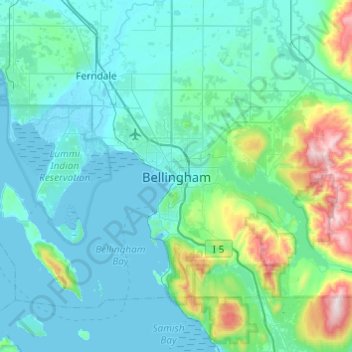
Nimi: Topografinen kartta Bellingham, korkeus, helpotus.
Keskimääräinen korkeus: 129 m
Minimi korkeus: -1 m
Maksimi korkeus: 1 002 m
Tee lahjoitus
Muut topografiset kartat
Napsauta karttaa nähdäksesi sen topografian, sen korkeus ja sen helpotuksen.
Whatcom Falls Park
United States > Washington > Whatcom County > Bellingham
Keskimääräinen korkeus: 75 m