
Tee lahjoitus
Topografinen kartta Wind River Range
Napsauta karttaa nähdäksesi korkeus.
Tee lahjoitus
Tietoja tästä kartasta
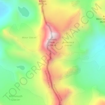
Nimi: Topografinen kartta Wind River Range, korkeus, helpotus.
Paikka: Wind River Range, Fremont County, Wyoming, United States (43.18031 -109.65386 43.18041 -109.65376)
Keskimääräinen korkeus: 3 706 m
Minimi korkeus: 3 338 m
Maksimi korkeus: 4 208 m
Tee lahjoitus
Muut topografiset kartat
Napsauta karttaa nähdäksesi sen topografian, sen korkeus ja sen helpotuksen.
Dubois
United States > Wyoming > Fremont County
Dubois is located at 43°32′9″N 109°38′9″W / 43.53583°N 109.63583°W / 43.53583; -109.63583 (43.535936, -109.635915) and an elevation of 2115 m (6940 ft). The Wind River runs through the town.
Keskimääräinen korkeus: 2 167 m
Tee lahjoitus
Tee lahjoitus
Sinks Canyon State Park
United States > Wyoming > Fremont County > Lander
Keskimääräinen korkeus: 2 133 m
Tee lahjoitus
Dubois
United States > Wyoming > Fremont County
Dubois is located at 43°32′9″N 109°38′9″W / 43.53583°N 109.63583°W / 43.53583; -109.63583 (43.535936, -109.635915) and an elevation of 2115 m (6940 ft). The Wind River runs through the town.
Keskimääräinen korkeus: 2 167 m