
Tee lahjoitus
Topografinen kartta Long Pond
Napsauta karttaa nähdäksesi korkeus.
Tee lahjoitus
Long Pond
Long Pond is named after the unique wetland topography formed by the Tunkhannock Creek. Within the Long Pond community, public access lands are owned and protected by The Bethlehem Authority, Nature Conservancy, Wildlands Conservancy County of Monroe Open Space Program, , PA Game Commission and PA Department of Forest and Waters. Long Pond is home to many species of unique plants and animals.
Tee lahjoitus
Tietoja tästä kartasta
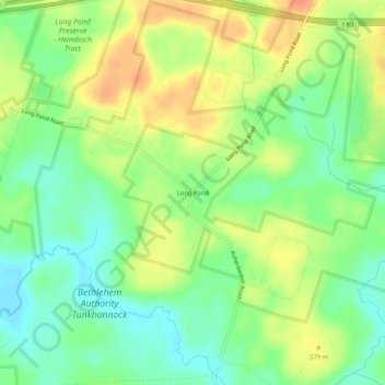
Nimi: Topografinen kartta Long Pond, korkeus, helpotus.
Keskimääräinen korkeus: 571 m
Minimi korkeus: 550 m
Maksimi korkeus: 596 m
Tee lahjoitus
Muut topografiset kartat
Napsauta karttaa nähdäksesi sen topografian, sen korkeus ja sen helpotuksen.
Indian Mountain Lake
United States > Pennsylvania > Monroe County > Tunkhannock Township > Indian Mountain Lake
Keskimääräinen korkeus: 506 m