
Kiitos, että tuet tätä sivustoa ❤️
Tee lahjoitus
Tee lahjoitus
Topografinen kartta Södertälje
Napsauta karttaa nähdäksesi korkeus.
Kiitos, että tuet tätä sivustoa ❤️
Tee lahjoitus
Tee lahjoitus
Södertälje
Due to its topography and the fact that it is divided by a canal, it has been difficult to build good train connections in and through the city. Despite this, Södertälje is one of the largest railway hubs in Sweden. When the railway to Södertälje was commissioned, it was decided that the main line would not be drawn through what was then the immediate city centre. The decision was one of the factors behind the urban planning of the area Mariekälla, just south of the Järnatullen city toll.
Kiitos, että tuet tätä sivustoa ❤️
Tee lahjoitus
Tee lahjoitus
Tietoja tästä kartasta
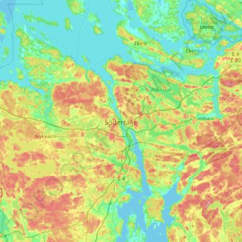
Nimi: Topografinen kartta Södertälje, korkeus, helpotus.
Keskimääräinen korkeus: 38 m
Minimi korkeus: -6 m
Maksimi korkeus: 81 m
Kiitos, että tuet tätä sivustoa ❤️
Tee lahjoitus
Tee lahjoitus