
Tee lahjoitus
Topografinen kartta Point Nepean
Napsauta karttaa nähdäksesi korkeus.
Tee lahjoitus
Tietoja tästä kartasta
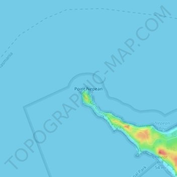
Nimi: Topografinen kartta Point Nepean, korkeus, helpotus.
Keskimääräinen korkeus: 1 m
Minimi korkeus: 0 m
Maksimi korkeus: 47 m
Tee lahjoitus
Muut topografiset kartat
Napsauta karttaa nähdäksesi sen topografian, sen korkeus ja sen helpotuksen.
Tee lahjoitus
Tee lahjoitus
Tee lahjoitus
Tee lahjoitus
Tee lahjoitus
Tee lahjoitus
Templestowe
Australia > Victoria > Melbourne
Gentle, rolling hills extend from east of the Yarra River flood plains, along Templestowe Road (towards the Eastern Freeway) for seven km (4.3 miles), to the north-east. The altitude of the plain above sea level is 50 m, and the topography is subdued and mostly flat; the hills are just below 60 m, the slopes…
Keskimääräinen korkeus: 66 m
Tee lahjoitus
Tee lahjoitus
Tee lahjoitus
Frankston
Australia > Victoria > Melbourne
Olivers Hill is the most prominent elevation in Frankston which rises to 55 metres above sea level (180 feet) at its highest point in the suburb. Its origins date to approximately 415 to 360 million years ago. Its base is Mount Eliza Granite dating from the Devonian period, which was covered in lava tuffs in…
Keskimääräinen korkeus: 40 m
Tee lahjoitus
St Andrews Beach
Australia > Victoria > Melbourne
St Andrews Beach features a unique topography known as The Cups Country, which creates an ideal environment for golf courses. Golfers have a choice of several nearby golf courses including the St Andrews Beach Club on Sandy Road, Moonah Links off Truemans Road, and The Dunes on Browns Road.
Keskimääräinen korkeus: 10 m
Tee lahjoitus
Fitzroy
Australia > Victoria > Melbourne
Fitzroy's topography is flat. It is laid out in grid plan and is characterised by a fairly tightly spaced rectangular grid of medium-sized streets, with many of its narrow streets and back lanes facilitating only one-way traffic. Its built form is a legacy of its early history when a mixture of land uses was…
Keskimääräinen korkeus: 35 m
Tee lahjoitus
Tee lahjoitus
Tee lahjoitus
Tee lahjoitus
Tee lahjoitus
Tee lahjoitus
Tee lahjoitus
Tee lahjoitus
Tee lahjoitus
Vermont South
Australia > Victoria > Melbourne
In 1966 the Metropolitan & Melbourne Board of Works (MMBW) put forth a plan to construct numerous "package" sewage treatment plants in the valleys of Dandenong Creek and its tributaries. The project aimed to provide adequate sewerage to the catchment before the Dandenong Valley Trunk sewer (DVT) could…
Keskimääräinen korkeus: 100 m
Tee lahjoitus
Mount Dandenong
Australia > Victoria > Melbourne
Mount Dandenong has an oceanic climate (Cfb) with warm summers and cool winters. The temperature usually is 3 - 7 °C (5.4 - 12.6 °F) cooler than downtown Melbourne due to its elevation and distance from the urban island heating effect of Melbourne.
Keskimääräinen korkeus: 408 m
Tee lahjoitus
Tee lahjoitus
Scoresby
Australia > Victoria > Melbourne
Scoresby has a weather station which collects data for the Bureau of Meteorology. It commenced readings in 1948 and is situated at Latitude 37.87°S and Longitude 145.26°E at an elevation of 80m above sea level. The site name is the Scoresby Research Institute and its site number is 086104, however it is not…
Keskimääräinen korkeus: 62 m
Tee lahjoitus
Tee lahjoitus