
Tee lahjoitus
Topografinen kartta Sconce Hill
Napsauta karttaa nähdäksesi korkeus.
Tee lahjoitus
Tietoja tästä kartasta
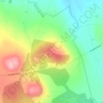
Nimi: Topografinen kartta Sconce Hill, korkeus, helpotus.
Keskimääräinen korkeus: 158 m
Minimi korkeus: 91 m
Maksimi korkeus: 254 m
Tee lahjoitus
Muut topografiset kartat
Napsauta karttaa nähdäksesi sen topografian, sen korkeus ja sen helpotuksen.
Drumahoe
United Kingdom > Northern Ireland > County Londonderry > Derry/Londonderry
Keskimääräinen korkeus: 46 m
Causeway Coast and Glens District
United Kingdom > Northern Ireland > County Londonderry
Keskimääräinen korkeus: 101 m
Ballymagroarty
United Kingdom > Northern Ireland > County Londonderry > Derry/Londonderry
Keskimääräinen korkeus: 73 m
Tee lahjoitus
Mid-Ulster District Council
United Kingdom > Northern Ireland > County Londonderry
Keskimääräinen korkeus: 112 m
Foyle
United Kingdom > Northern Ireland > County Londonderry > Derry/Londonderry
Keskimääräinen korkeus: 48 m
River Roe
United Kingdom > Northern Ireland > County Londonderry > Limavady
Keskimääräinen korkeus: 27 m
Tee lahjoitus
Lough Foyle
United Kingdom > Northern Ireland > County Londonderry > Londonderry/Derry
Keskimääräinen korkeus: 61 m
Foyle
United Kingdom > Northern Ireland > County Londonderry > Derry/Londonderry
Keskimääräinen korkeus: 48 m
Bay Road Park
United Kingdom > Northern Ireland > County Londonderry > Derry/Londonderry
Keskimääräinen korkeus: 19 m
Tee lahjoitus