
Tee lahjoitus
Topografinen kartta Twin Falls (Lower)
Napsauta karttaa nähdäksesi korkeus.
Tee lahjoitus
Tietoja tästä kartasta
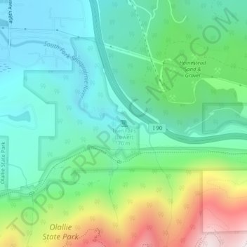
Nimi: Topografinen kartta Twin Falls (Lower), korkeus, helpotus.
Keskimääräinen korkeus: 458 m
Minimi korkeus: 176 m
Maksimi korkeus: 1 167 m
Tee lahjoitus
Muut topografiset kartat
Napsauta karttaa nähdäksesi sen topografian, sen korkeus ja sen helpotuksen.
Fritz Hedges Waterway Park
United States > Washington > King County > Seattle
Keskimääräinen korkeus: 32 m
Tee lahjoitus
Lake Marcel
United States > Washington > King County
Lake Marcel is at an altitude of 295 feet (90 m) above sea level. The lake sits in a bowl at the top of Stillwater Hill on the east side of the Snoqualmie Valley, north of Carnation. It has two main areas of water connected by a channel, and several peninsular features make an extensive shoreline around the…
Keskimääräinen korkeus: 110 m
Tee lahjoitus
Warren G. Magnuson Park
United States > Washington > King County > Seattle
Keskimääräinen korkeus: 19 m
Snoqualmie River
United States > Washington > King County
The Middle Fork Valley is a popular recreational area since it is accessible during the winter due to its low altitude and close proximity to Seattle. For many years the Middle Fork Road extended 24 miles to Hardscrabble Creek, but was gated at Dingford Creek in June 2007, 18 miles in. The gate at Dingford…
Keskimääräinen korkeus: 212 m
Tee lahjoitus
Muckleshoot Tribe Reservation
United States > Washington > King County > Auburn
Keskimääräinen korkeus: 163 m
Clyde Hill
United States > Washington > King County
The top elevation is close to 375 feet. There are approximately 21 miles of public roadways in Clyde Hill.
Keskimääräinen korkeus: 48 m
Union Bay Natural Area
United States > Washington > King County > Seattle
Keskimääräinen korkeus: 24 m
Tee lahjoitus
Tee lahjoitus
Lakeland North
United States > Washington > King County > Lakeland North
Keskimääräinen korkeus: 113 m
Mercer Island
United States > Washington > King County > Mercer Island
Mercer Island City Hall is located at 47°34′39″N 122°12′43.2″W / 47.57750°N 122.212000°W / 47.57750; -122.212000 (47.5775, -122.212). The peak elevation in the city is about 338 feet (103 m), near the center of the island.
Keskimääräinen korkeus: 39 m
Tee lahjoitus
Tee lahjoitus
Donnie Chin International Children’s Park
United States > Washington > King County > Seattle
Keskimääräinen korkeus: 43 m
West Tiger Mountain Natural Resource Conservation Area
United States > Washington > King County > Issaquah
Keskimääräinen korkeus: 101 m
Tee lahjoitus