Geolocate
👉 Easily get elevation data in JSON, GeoTIFF and KML formats using Elevation API
Kiitos, että tuet tätä sivustoa ❤️
Tee lahjoitus

Topografinen kartta Mount Annan

Napsauta karttaa nähdäksesi korkeus.

👉 Easily get elevation data in JSON, GeoTIFF and KML formats using Elevation API
Kiitos, että tuet tätä sivustoa ❤️
Tee lahjoitus

Tietoja tästä kartasta

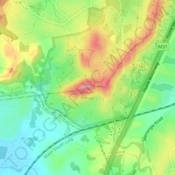
Nimi: Topografinen kartta Mount Annan, korkeus, helpotus.

Paikka: Mount Annan, Sydney, Campbelltown City Council, New South Wales, 2563, Australia (-34.07833 150.76318 -34.07823 150.76328)

Keskimääräinen korkeus: 115 m

Minimi korkeus: 68 m

Maksimi korkeus: 176 m

Muut topografiset kartat

Napsauta karttaa nähdäksesi sen topografian, sen korkeus ja sen helpotuksen.

Windsor

Australia > New South Wales > Sydney

Keskimääräinen korkeus: 12 m

Penrith

Australia > New South Wales > Sydney > Penrith

Penrith is a city in New South Wales, Australia, located in Greater Western Sydney, 55 kilometres (31 mi) west of the Sydney central business district on the banks of the Nepean River, on the outskirts of the Cumberland Plain. Its elevation is 32 metres (105 ft).

Keskimääräinen korkeus: 34 m

Leumeah

Australia > New South Wales > Sydney

Keskimääräinen korkeus: 83 m

Eastwood

Australia > New South Wales > Sydney

Keskimääräinen korkeus: 80 m

Pendle Creek

Australia > New South Wales > Sydney

Keskimääräinen korkeus: 43 m

The Ponds

Australia > New South Wales > Sydney

Keskimääräinen korkeus: 60 m

Narrabeen

Australia > New South Wales > Sydney

Keskimääräinen korkeus: 17 m

Northbridge

Australia > New South Wales > Sydney

Keskimääräinen korkeus: 53 m

Winston Hills

Australia > New South Wales > Sydney

Keskimääräinen korkeus: 58 m

Sydney CBD

Australia > New South Wales > Sydney

Keskimääräinen korkeus: 25 m

Wolli Creek

Australia > New South Wales > Sydney

Keskimääräinen korkeus: 27 m

Mosman

Australia > New South Wales > Sydney

Keskimääräinen korkeus: 29 m

Rozelle

Australia > New South Wales > Sydney

Keskimääräinen korkeus: 16 m

Balmain

Australia > New South Wales > Sydney

Keskimääräinen korkeus: 12 m

Manly Vale

Australia > New South Wales > Sydney

Keskimääräinen korkeus: 34 m

Bundeena

Australia > New South Wales > Sydney

Keskimääräinen korkeus: 20 m

North Sydney

Australia > New South Wales > Sydney

Keskimääräinen korkeus: 50 m

Marrickville

Australia > New South Wales > Sydney

Keskimääräinen korkeus: 17 m

Sydney

Australia > New South Wales > Sydney

Keskimääräinen korkeus: 23 m

Ryde

Australia > New South Wales > Sydney

Keskimääräinen korkeus: 52 m

Whalan

Australia > New South Wales > Sydney

Keskimääräinen korkeus: 48 m

Castle Hill

Australia > New South Wales > Sydney

Keskimääräinen korkeus: 123 m

Inner West

Australia > New South Wales > Sydney

Keskimääräinen korkeus: 19 m

Frenchs Forest

Australia > New South Wales > Sydney

Keskimääräinen korkeus: 110 m

Glenfield

Australia > New South Wales > Sydney

Keskimääräinen korkeus: 29 m

Pitt Town

Australia > New South Wales > Sydney

Keskimääräinen korkeus: 19 m

Hornsby

Australia > New South Wales > Sydney

Keskimääräinen korkeus: 160 m

Northern Beaches

Australia > New South Wales > Sydney

Keskimääräinen korkeus: 67 m

Sydney Water Supply Canal

Australia > New South Wales > Sydney

Keskimääräinen korkeus: 86 m

Newport

Australia > New South Wales > Sydney

Keskimääräinen korkeus: 27 m

Woodford

Australia > New South Wales > Sydney

Woodford is a village in the Blue Mountains in New South Wales, Australia, about 90 kilometres west of Sydney. Its elevation is 609 metres (1,998 ft) above sea level. It is situated on the Great Western Highway and has a railway station (opened in 1868 as Buss's Platform) on the Main Western railway line…

Keskimääräinen korkeus: 544 m

Wicks Park

Australia > New South Wales > Sydney

Keskimääräinen korkeus: 17 m

Waverton

Australia > New South Wales > Sydney

Keskimääräinen korkeus: 33 m

Meadowbank Park

Australia > New South Wales > Sydney

Keskimääräinen korkeus: 14 m

Beaman Park

Australia > New South Wales > Sydney

Keskimääräinen korkeus: 23 m

Browns Waterhole

Australia > New South Wales > Sydney

Keskimääräinen korkeus: 73 m

Eric Primrose Reserve

Australia > New South Wales > Sydney

Keskimääräinen korkeus: 15 m

Valley Reserve

Australia > New South Wales > Sydney > Campbelltown

Keskimääräinen korkeus: 102 m

Sir Thomas Mitchell Reserve

Australia > New South Wales > Sydney

Keskimääräinen korkeus: 75 m

Darlinghurst

Australia > New South Wales > Sydney

Keskimääräinen korkeus: 38 m

Macquarie Park

Australia > New South Wales > Sydney

Keskimääräinen korkeus: 59 m

Drummoyne

Australia > New South Wales > Sydney

Keskimääräinen korkeus: 11 m

Terrey Hills

Australia > New South Wales > Sydney

Owing to its elevation and close proximity to the ocean, as well as its extensive tree canopy cover, the weather station at Terrey Hills records the mildest temperatures of any weather station in the Greater Sydney region. Under Köppen's scheme, the suburb has a borderline humid subtropical (Cfa) and oceanic…

Keskimääräinen korkeus: 146 m

Kemps Creek

Australia > New South Wales > Sydney

Keskimääräinen korkeus: 57 m

Glebe

Australia > New South Wales > Sydney

Keskimääräinen korkeus: 18 m

Badgerys Creek

Australia > New South Wales > Sydney

Keskimääräinen korkeus: 88 m

King George Park

Australia > New South Wales > Sydney

Keskimääräinen korkeus: 16 m

Rooty Hill

Australia > New South Wales > Sydney

Keskimääräinen korkeus: 52 m

Neutral Bay

Australia > New South Wales > Sydney

Keskimääräinen korkeus: 53 m

Sutherland

Australia > New South Wales > Sydney

Keskimääräinen korkeus: 80 m

Heathcote National Park

Australia > New South Wales > Sydney

Keskimääräinen korkeus: 178 m

Cooks River

Australia > New South Wales > Sydney

Keskimääräinen korkeus: 29 m

Sydney Park

Australia > New South Wales > Sydney

Keskimääräinen korkeus: 13 m

North Narrabeen Beach

Australia > New South Wales > Sydney

Keskimääräinen korkeus: 5 m

Milson Island

Australia > New South Wales > Sydney > Milsons Passage

Keskimääräinen korkeus: 29 m

Longneck Lagoon

Australia > New South Wales > Sydney

Keskimääräinen korkeus: 21 m

Alexandria

Australia > New South Wales > Sydney

Keskimääräinen korkeus: 17 m

Lane Cove River

Australia > New South Wales > Sydney

Keskimääräinen korkeus: 154 m

Western Sydney Parklands

Australia > New South Wales > Sydney

Keskimääräinen korkeus: 45 m

Arthur Phillip Park

Australia > New South Wales > Sydney

Keskimääräinen korkeus: 29 m

Prince Alfred Square

Australia > New South Wales > Sydney > Parramatta

Keskimääräinen korkeus: 22 m

St Vincents Playground

Australia > New South Wales > Sydney

Keskimääräinen korkeus: 51 m

Canberra Road Reserve

Australia > New South Wales > Sydney

Keskimääräinen korkeus: 12 m

Berry Reserve

Australia > New South Wales > Sydney

Keskimääräinen korkeus: 15 m

Long Reef

Australia > New South Wales > Sydney

Keskimääräinen korkeus: 1 m

Wyagdon Street Reserve

Australia > New South Wales > Sydney

Keskimääräinen korkeus: 60 m

Denistone

Australia > New South Wales > Sydney

Keskimääräinen korkeus: 60 m

Sydney Water Supply Canal

Australia > New South Wales > Sydney

Keskimääräinen korkeus: 134 m

Springbrook Boulevard Reserve

Australia > New South Wales > Sydney

Keskimääräinen korkeus: 60 m

Newport Beach

Australia > New South Wales > Sydney

Keskimääräinen korkeus: 31 m

One More Shot Pond

Australia > New South Wales > Sydney

Keskimääräinen korkeus: 59 m

Observatory Hill Park

Australia > New South Wales > Sydney

Keskimääräinen korkeus: 14 m

Clovelly Beach

Australia > New South Wales > Sydney

Keskimääräinen korkeus: 22 m

Warners Park

Australia > New South Wales > Sydney

Keskimääräinen korkeus: 62 m

Plumpton

Australia > New South Wales > Sydney

Keskimääräinen korkeus: 48 m

Lake Sedgwick

Australia > New South Wales > Sydney

Keskimääräinen korkeus: 117 m

Mount Annan Botanic Garden

Australia > New South Wales > Sydney

Keskimääräinen korkeus: 115 m

Freshwater Beach

Australia > New South Wales > Sydney

Keskimääräinen korkeus: 11 m

Bells Creek

Australia > New South Wales > Sydney

Keskimääräinen korkeus: 34 m

Warragamba Dam

Australia > New South Wales > Sydney > Warragamba

Keskimääräinen korkeus: 156 m

Willowdale Dog Park

Australia > New South Wales > Sydney

Keskimääräinen korkeus: 105 m

Buffalo Creek Reserve

Australia > New South Wales > Sydney

Keskimääräinen korkeus: 34 m

Reg Coady Reserve

Australia > New South Wales > Sydney

Keskimääräinen korkeus: 14 m

Hyde Park South

Australia > New South Wales > Sydney

Keskimääräinen korkeus: 31 m

Sydney Water Supply Canal

Australia > New South Wales > Sydney

Keskimääräinen korkeus: 102 m

Pyes Creek

Australia > New South Wales > Sydney

Keskimääräinen korkeus: 168 m

Vineyard Creek

Australia > New South Wales > Sydney > Parramatta

Keskimääräinen korkeus: 24 m

Duck River

Australia > New South Wales > Sydney

Keskimääräinen korkeus: 14 m

Innisfall Park

Australia > New South Wales > Sydney

Keskimääräinen korkeus: 31 m

Sydney Water Supply Canal

Australia > New South Wales > Sydney

Keskimääräinen korkeus: 98 m

Salt Pan Creek

Australia > New South Wales > Sydney

Keskimääräinen korkeus: 20 m

Cattai Creek

Australia > New South Wales > Sydney

Keskimääräinen korkeus: 30 m

Ward Park

Australia > New South Wales > Sydney

Keskimääräinen korkeus: 36 m

Sydney Water Supply Canal

Australia > New South Wales > Sydney

Keskimääräinen korkeus: 114 m

Tambourine Creek

Australia > New South Wales > Sydney

Keskimääräinen korkeus: 39 m

Bridge Road Reserve

Australia > New South Wales > Sydney

Keskimääräinen korkeus: 32 m

Hill Road Reserve

Australia > New South Wales > Sydney

Keskimääräinen korkeus: 115 m

Victoria Square

Australia > New South Wales > Sydney

Keskimääräinen korkeus: 30 m

Fred Caterson Reserve

Australia > New South Wales > Sydney

Keskimääräinen korkeus: 94 m

Village Park

Australia > New South Wales > Sydney > Mona Vale

Keskimääräinen korkeus: 16 m