
Tee lahjoitus
Topografinen kartta Ballintoy
Napsauta karttaa nähdäksesi korkeus.
Tee lahjoitus
Tietoja tästä kartasta
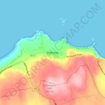
Nimi: Topografinen kartta Ballintoy, korkeus, helpotus.
Keskimääräinen korkeus: 73 m
Minimi korkeus: -1 m
Maksimi korkeus: 206 m
Tee lahjoitus
Muut topografiset kartat
Napsauta karttaa nähdäksesi sen topografian, sen korkeus ja sen helpotuksen.
Botanic Gardens
United Kingdom > Northern Ireland > County Antrim > Belfast
Keskimääräinen korkeus: 15 m
Rathlin Island
United Kingdom > Northern Ireland > County Antrim > Church Bay
Keskimääräinen korkeus: 10 m
Tee lahjoitus
Loughgiel Millennium Centre
United Kingdom > Northern Ireland > County Antrim > Loughguile
Keskimääräinen korkeus: 155 m
Ballygomartin
United Kingdom > Northern Ireland > County Antrim > Belfast
Keskimääräinen korkeus: 258 m
Tee lahjoitus
Shane's Castle Park
United Kingdom > Northern Ireland > County Antrim > Randalstown
Keskimääräinen korkeus: 30 m
Lagan Navigation (Abandoned)
United Kingdom > Northern Ireland > County Antrim > Belfast
Keskimääräinen korkeus: 29 m
Mid and East Antrim District
United Kingdom > Northern Ireland > County Antrim
Keskimääräinen korkeus: 111 m
Tee lahjoitus
Antrim and Newtownabbey District
United Kingdom > Northern Ireland > County Antrim
Keskimääräinen korkeus: 97 m
Kilroot
United Kingdom > Northern Ireland > County Antrim > Carrickfergus
Keskimääräinen korkeus: 28 m
Tee lahjoitus
Causeway Coast AONB
United Kingdom > Northern Ireland > County Antrim > Ballintoy
Keskimääräinen korkeus: 34 m
Tamybuck
United Kingdom > Northern Ireland > County Antrim > Aughafatten
Keskimääräinen korkeus: 171 m
Kinbane Castle
United Kingdom > Northern Ireland > County Antrim > Ballycastle
Keskimääräinen korkeus: 37 m
Rathlin Island
United Kingdom > Northern Ireland > County Antrim > Church Bay
Keskimääräinen korkeus: 10 m
Tee lahjoitus
Antrim and Newtownabbey District
United Kingdom > Northern Ireland > County Antrim
Keskimääräinen korkeus: 97 m
Tee lahjoitus
Tee lahjoitus
Tee lahjoitus
Mid and East Antrim District
United Kingdom > Northern Ireland > County Antrim
Keskimääräinen korkeus: 111 m
Tee lahjoitus
Antrim and Newtownabbey District
United Kingdom > Northern Ireland > County Antrim
Keskimääräinen korkeus: 97 m