
Tee lahjoitus
Topografinen kartta Reineberg
Napsauta karttaa nähdäksesi korkeus.
Tee lahjoitus
Reineberg
The Reineberg is a hill on the Wiehen ridge, south of the town of Lübbecke. With a height of 275.9 m above sea level it is, from a topographical point of view, not a particularly impressive eminence in this part of the Wiehen Hills, because, in the immediate vicinity are considerably higher summits, such as the 320 m high Heidbrink just under 1 km to the south. East of the Reinberg on the other side of a valley bottom rises the Heidkopf, west of the Meesenkopf, on the summit of which there was once a fortification. 230 metres southwest of the summit lies the Wittekind Spring, that had a certain importance for the garrison of the castle at the summit, but today is just a small pond by a rock outcrop at the edge of a track. The Reineberg, which is the local hill for the town of Lübbecke, owes its significance to the fact that, until 1723, the year of its demolition, Reineberg Castle (German: Burg Reineberg or Reineburg) stood here.
Tee lahjoitus
Tietoja tästä kartasta
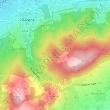
Nimi: Topografinen kartta Reineberg, korkeus, helpotus.
Keskimääräinen korkeus: 181 m
Minimi korkeus: 69 m
Maksimi korkeus: 310 m
Tee lahjoitus
Muut topografiset kartat
Napsauta karttaa nähdäksesi sen topografian, sen korkeus ja sen helpotuksen.
32312
Germany > North Rhine-Westphalia > Kreis Minden-Lübbecke > Lübbecke
Keskimääräinen korkeus: 96 m