
Tee lahjoitus
Topografinen kartta Waterville
Napsauta karttaa nähdäksesi korkeus.
Tee lahjoitus
Tietoja tästä kartasta
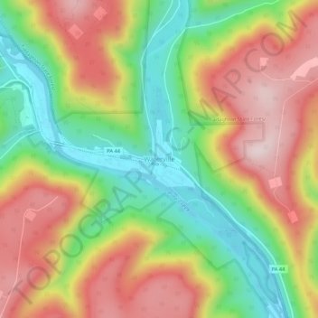
Nimi: Topografinen kartta Waterville, korkeus, helpotus.
Paikka: Waterville, Lycoming County, Pennsylvania, United States (41.28851 -77.38201 41.32851 -77.34201)
Keskimääräinen korkeus: 390 m
Minimi korkeus: 173 m
Maksimi korkeus: 616 m
Tee lahjoitus
Muut topografiset kartat
Napsauta karttaa nähdäksesi sen topografian, sen korkeus ja sen helpotuksen.
Cascade Township
United States > Pennsylvania > Lycoming County
According to the United States Census Bureau, the township has a total area of 39.5 square miles (102.4 km2), of which 39.2 square miles (101.5 km2) are land and 0.3 square miles (0.8 km2), or 0.81%, are water. The northern part of the township drains to Pleasant Stream, which flows west to join Lycoming Creek…
Keskimääräinen korkeus: 459 m
Tee lahjoitus
Brandon Park
United States > Pennsylvania > Lycoming County > Williamsport
Keskimääräinen korkeus: 179 m
Tee lahjoitus
Tee lahjoitus
McHenry Township
United States > Pennsylvania > Lycoming County
According to the United States Census Bureau, the township has a total area of 76.7 square miles (198.6 km2), of which 76.2 square miles (197.4 km2) are land and 0.46 square miles (1.2 km2), or 0.62%, are water. Pine Creek runs through the center of the township at the bottom of Pine Creek Gorge, with creek…
Keskimääräinen korkeus: 506 m
Cascade Township
United States > Pennsylvania > Lycoming County
According to the United States Census Bureau, the township has a total area of 39.5 square miles (102.4 km2), of which 39.2 square miles (101.5 km2) are land and 0.3 square miles (0.8 km2), or 0.81%, are water. The northern part of the township drains to Pleasant Stream, which flows west to join Lycoming Creek…
Keskimääräinen korkeus: 459 m
Tee lahjoitus
Tee lahjoitus
Hughesville
United States > Pennsylvania > Lycoming County > Hughesville
Keskimääräinen korkeus: 182 m