
Tee lahjoitus
Topografinen kartta Bendigo
Napsauta karttaa nähdäksesi korkeus.
Tee lahjoitus
Tietoja tästä kartasta
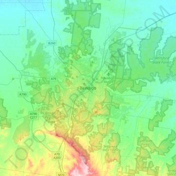
Nimi: Topografinen kartta Bendigo, korkeus, helpotus.
Keskimääräinen korkeus: 223 m
Minimi korkeus: 139 m
Maksimi korkeus: 535 m
Tee lahjoitus
Muut topografiset kartat
Napsauta karttaa nähdäksesi sen topografian, sen korkeus ja sen helpotuksen.
City of Melbourne
Melbourne's topography is characterized by a diverse landscape that transitions from flat coastal plains to rolling hills and mountainous regions. The city is situated at the northern end of Port Phillip Bay, where the terrain is predominantly flat, facilitating urban development. As one moves eastward, the…
Keskimääräinen korkeus: 18 m
Melbourne
Melbourne is also prone to isolated convective showers forming when a cold pool crosses the state, especially if there is considerable daytime heating. These showers are often heavy and can include hail, squalls, and significant drops in temperature, but they often pass through very quickly with a rapid…
Keskimääräinen korkeus: 185 m
Tee lahjoitus
Tee lahjoitus
Tee lahjoitus
Frankston
Australia > Victoria > Melbourne
Olivers Hill is the most prominent elevation in Frankston which rises to 55 metres above sea level (180 feet) at its highest point in the suburb. Its origins date to approximately 415 to 360 million years ago. Its base is Mount Eliza Granite dating from the Devonian period, which was covered in lava tuffs in…
Keskimääräinen korkeus: 40 m
Tee lahjoitus
Tee lahjoitus
Beaufort
Beaufort has an elevation-influenced oceanic climate (Köppen: Cfb), with tepid, relatively dry summers and cool, wetter winters. Average maxima vary from 25.3 °C (77.5 °F) in January to 10.1 °C (50.2 °F) in July, while average minima fluctuate between 11.5 °C (52.7 °F) in February and 3.2 °C (37.8 °F)…
Keskimääräinen korkeus: 390 m
Tee lahjoitus
Tee lahjoitus
Tee lahjoitus
Tee lahjoitus
Tee lahjoitus
Tee lahjoitus
Mount Dandenong
Australia > Victoria > Melbourne
Mount Dandenong has an oceanic climate (Cfb) with warm summers and cool winters. The temperature usually is 3 - 7 °C (5.4 - 12.6 °F) cooler than downtown Melbourne due to its elevation and distance from the urban island heating effect of Melbourne.
Keskimääräinen korkeus: 408 m
Mount Buller
Due to its far south-western location in the alpine region, Mount Buller is more susceptible to cold airmasses which allow it to record some of the lowest maximum temperatures and daytime readings in the country, despite being considerably lower in elevation than other mountain sites to the north-east. On 5…
Keskimääräinen korkeus: 824 m
Tee lahjoitus
Tee lahjoitus
Tee lahjoitus
Tee lahjoitus
Grampians National Park
Mount William is known within the gliding community for the "Grampians Wave", a weather phenomenon that sometimes enables glider pilots to reach extreme altitudes of the order of 28,000 ft (8,500 m). This predominantly occurs during the months of May, June, September and October when strong westerly winds flow…
Keskimääräinen korkeus: 262 m
Falls Creek
Australia > Victoria > Falls Creek Alpine Resort
The Falls Creek Alpine Resort is an alpine ski resort in the Hume region in northeastern Victoria, Australia. It is located in the Alpine National Park in the Victorian Alps, approximately 350 kilometres (220 miles) by road from Melbourne, with the nearest town being Mount Beauty, which is approximately 30 km…
Keskimääräinen korkeus: 1 459 m
Tee lahjoitus
Tee lahjoitus
Tee lahjoitus
Trentham
Trentham is a small town in the Shire of Hepburn and Shire of Moorabool local government area, Victoria, Australia. At the 2016 census, Trentham had a population of 1,180, with a median age of 55 years. Located at an altitude of 700 metres (2,297 ft), the town is 87 kilometres (54 mi) north-west of Melbourne.
Keskimääräinen korkeus: 702 m
Tee lahjoitus
King River
The King River rises below Mount Buggery, within Mansfield Shire, at an elevation exceeding 1,460 metres (4,790 ft) above sea level. The river flows generally north by northwest, most of its course through remote parts of the Alpine and Mount Buffalo national parks, and then descending into the King Valley,…
Keskimääräinen korkeus: 467 m
Tee lahjoitus
Tee lahjoitus
Tee lahjoitus
Tee lahjoitus
Tee lahjoitus
Tee lahjoitus