Geolocate

Topografinen kartta Burns Bay

Napsauta karttaa nähdäksesi korkeus.

Tietoja tästä kartasta

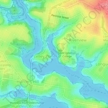
Nimi: Topografinen kartta Burns Bay, korkeus, helpotus.

Paikka: Burns Bay, Sydney, New South Wales, 2110, Australia (-33.82673 151.15287 -33.82663 151.15297)

Keskimääräinen korkeus: 27 m

Minimi korkeus: -4 m

Maksimi korkeus: 84 m

Muut topografiset kartat

Napsauta karttaa nähdäksesi sen topografian, sen korkeus ja sen helpotuksen.

Box Hill

Australia > New South Wales > Sydney

Keskimääräinen korkeus: 45 m

Northern Beaches

Australia > New South Wales > Sydney

Keskimääräinen korkeus: 67 m

Moore Park

Australia > New South Wales > Sydney

Keskimääräinen korkeus: 43 m

Kurnell

Australia > New South Wales > Sydney

Keskimääräinen korkeus: 4 m

Millers Point

Australia > New South Wales > Sydney

Keskimääräinen korkeus: 14 m

Bondi Beach

Australia > New South Wales > Sydney

Keskimääräinen korkeus: 31 m

Liverpool

Australia > New South Wales > Sydney

Keskimääräinen korkeus: 14 m

Holsworthy

Australia > New South Wales > Sydney

Keskimääräinen korkeus: 121 m

Northbridge

Australia > New South Wales > Sydney

Keskimääräinen korkeus: 53 m

Sydney

Australia > New South Wales > Sydney

Keskimääräinen korkeus: 23 m

Lane Cove National Park

Australia > New South Wales > Sydney

The park includes areas of land which are part of Ku-ring-gai, Ryde, and Hornsby local government areas with small areas of the park in Willoughby, Lane Cove and Hunter's Hill local government areas on the banks of the lower reaches of the river. The park is surrounded on all sides by developed suburban areas…

Keskimääräinen korkeus: 81 m

Northern Beaches Council

Australia > New South Wales > Sydney

Keskimääräinen korkeus: 67 m

Ingleburn

Australia > New South Wales > Sydney

Keskimääräinen korkeus: 56 m

Hurstville

Australia > New South Wales > Sydney

Keskimääräinen korkeus: 50 m

Lilyfield

Australia > New South Wales > Sydney

Keskimääräinen korkeus: 18 m

Merrylands

Australia > New South Wales > Sydney

Keskimääräinen korkeus: 31 m

Panania

Australia > New South Wales > Sydney

Keskimääräinen korkeus: 17 m

Sydney Olympic Park

Australia > New South Wales > Sydney

Keskimääräinen korkeus: 9 m

Casula

Australia > New South Wales > Sydney

Casula is the first suburb immediately south of Liverpool on the Hume Highway and the Main Southern railway line between Sydney and Melbourne. Casula consists of undulating, gently rolling land, with elevations across the suburb being mostly between 30 and 70 metres above sea level. The Georges River forms the…

Keskimääräinen korkeus: 34 m

Alexandria

Australia > New South Wales > Sydney

Keskimääräinen korkeus: 17 m

Whale Beach

Australia > New South Wales > Sydney

Keskimääräinen korkeus: 17 m

Mortdale

Australia > New South Wales > Sydney

Keskimääräinen korkeus: 38 m

Jamison Valley

Australia > New South Wales > Sydney > Leura

South of Mount Solitary, the valley sprawls through Cedar and Kedumba Valley down to Coxs River and Lake Burragorang, the lake that was created when Warragamba Dam was built. There is a 3 kilometres (1.9 mi) prohibited area around the river and lake to protect Sydney's water supply. Around this area there is a…

Keskimääräinen korkeus: 578 m

Edensor Park

Australia > New South Wales > Sydney

Keskimääräinen korkeus: 57 m

Waverton

Australia > New South Wales > Sydney

Keskimääräinen korkeus: 33 m

Macquarie Park

Australia > New South Wales > Sydney

Keskimääräinen korkeus: 59 m

Wolli Creek

Australia > New South Wales > Sydney

Keskimääräinen korkeus: 27 m

Beecroft

Australia > New South Wales > Sydney

Keskimääräinen korkeus: 125 m

Centennial Park

Australia > New South Wales > Sydney

Keskimääräinen korkeus: 51 m

Longneck Lagoon

Australia > New South Wales > Sydney

Keskimääräinen korkeus: 21 m

Scotland Island

Australia > New South Wales > Sydney

Keskimääräinen korkeus: 17 m

Woodford

Australia > New South Wales > Sydney

Woodford is a village in the Blue Mountains in New South Wales, Australia, about 90 kilometres west of Sydney. Its elevation is 609 metres (1,998 ft) above sea level. It is situated on the Great Western Highway and has a railway station (opened in 1868 as Buss's Platform) on the Main Western railway line…

Keskimääräinen korkeus: 544 m

Wicks Park

Australia > New South Wales > Sydney

Keskimääräinen korkeus: 17 m

Oyster Bay

Australia > New South Wales > Sydney

Keskimääräinen korkeus: 25 m

Darlinghurst

Australia > New South Wales > Sydney

Keskimääräinen korkeus: 38 m

Galston

Australia > New South Wales > Sydney

Keskimääräinen korkeus: 167 m

Leichhardt

Australia > New South Wales > Sydney

Keskimääräinen korkeus: 22 m

Eastwood

Australia > New South Wales > Sydney

Keskimääräinen korkeus: 80 m

Rydalmere

Australia > New South Wales > Sydney

Keskimääräinen korkeus: 19 m

Botany Bay

Australia > New South Wales > Sydney

Keskimääräinen korkeus: 8 m

Mona Vale

Australia > New South Wales > Sydney

Keskimääräinen korkeus: 20 m

Berowra

Australia > New South Wales > Sydney

Berowra is located 44 kilometres north of the Sydney CBD and lies at an altitude of 215 metres. Surrounded by bushland, it borders the national parks of both the Berowra Valley and Ku-ring-gai Chase.

Keskimääräinen korkeus: 144 m

Windsor

Australia > New South Wales > Sydney

Keskimääräinen korkeus: 12 m

Petersham

Australia > New South Wales > Sydney

Keskimääräinen korkeus: 26 m

Roseville

Australia > New South Wales > Sydney

Keskimääräinen korkeus: 84 m

Leppington

Australia > New South Wales > Sydney

Keskimääräinen korkeus: 89 m

Westmead

Australia > New South Wales > Sydney

Keskimääräinen korkeus: 26 m

Cronulla

Australia > New South Wales > Sydney

Keskimääräinen korkeus: 8 m

Engadine

Australia > New South Wales > Sydney

Keskimääräinen korkeus: 121 m

Balgowlah

Australia > New South Wales > Sydney

Keskimääräinen korkeus: 40 m

Concord West

Australia > New South Wales > Sydney

Keskimääräinen korkeus: 9 m

Wentworth Falls

Australia > New South Wales > Sydney

Wentworth Falls (postcode: 2782) is a town in the Blue Mountains region of New South Wales, situated approximately 100 kilometres (62 mi) west of the Sydney central business district, and about 8 kilometres (5.0 mi) east of Katoomba, Australia on the Great Western Highway, with a Wentworth Falls railway…

Keskimääräinen korkeus: 708 m

Miranda

Australia > New South Wales > Sydney

Keskimääräinen korkeus: 31 m

Sackville North

Australia > New South Wales > Sydney

Keskimääräinen korkeus: 37 m

Ku-ring-gai Chase National Park

Australia > New South Wales > Sydney

Ku-ring-gai Chase is part of the Hornsby Plateau, a massive block of sandstone tilting upwards to the north. The park comprises a plateau with an elevation of generally 150–200 m above sea level. Between 250 and 200 million years ago, sand silt and mud was deposited by rivers across flood plains. These…

Keskimääräinen korkeus: 83 m

Strathfield

Australia > New South Wales > Sydney

Keskimääräinen korkeus: 26 m

Wollstonecraft

Australia > New South Wales > Sydney

Keskimääräinen korkeus: 52 m

Clovelly Beach

Australia > New South Wales > Sydney

Keskimääräinen korkeus: 22 m

Pratten Park

Australia > New South Wales > Sydney

Keskimääräinen korkeus: 29 m

East Gordon Park

Australia > New South Wales > Sydney

Keskimääräinen korkeus: 107 m

Cabarita Park

Australia > New South Wales > Sydney

Keskimääräinen korkeus: 11 m

Minto

Australia > New South Wales > Sydney

Keskimääräinen korkeus: 72 m

Rockdale

Australia > New South Wales > Sydney

Keskimääräinen korkeus: 20 m

Bella Vista

Australia > New South Wales > Sydney

Keskimääräinen korkeus: 79 m

Berkshire Park

Australia > New South Wales > Sydney

Keskimääräinen korkeus: 27 m

St Leonards

Australia > New South Wales > Sydney

Keskimääräinen korkeus: 69 m

Meadowbank Park

Australia > New South Wales > Sydney

Keskimääräinen korkeus: 14 m

Denistone West

Australia > New South Wales > Sydney

Keskimääräinen korkeus: 55 m

Nelson

Australia > New South Wales > Sydney

Keskimääräinen korkeus: 47 m

Beaconsfield

Australia > New South Wales > Sydney

Keskimääräinen korkeus: 18 m

Smithfield

Australia > New South Wales > Sydney

Established in 1836, Smithfield was the first major settlement of the Fairfield LGA. The original 1838 summary plan of Smithfield shows the suburb laid out in a grid pattern with most of the streets having the same names as they do today. Its altitude ranges from 21 to 48 m (69 to 157 ft) above sea level.…

Keskimääräinen korkeus: 33 m

Beaman Park

Australia > New South Wales > Sydney

Keskimääräinen korkeus: 23 m

Browns Waterhole

Australia > New South Wales > Sydney

Keskimääräinen korkeus: 73 m

Holroyd

Australia > New South Wales > Sydney

Keskimääräinen korkeus: 24 m

Eric Primrose Reserve

Australia > New South Wales > Sydney

Keskimääräinen korkeus: 15 m

Valley Reserve

Australia > New South Wales > Sydney > Campbelltown

Keskimääräinen korkeus: 102 m

Richmond Lowlands

Australia > New South Wales > Sydney

Keskimääräinen korkeus: 13 m

Sir Thomas Mitchell Reserve

Australia > New South Wales > Sydney

Keskimääräinen korkeus: 75 m

Killarney Heights

Australia > New South Wales > Sydney

Keskimääräinen korkeus: 72 m

North Curl Curl

Australia > New South Wales > Sydney

Keskimääräinen korkeus: 22 m

Sans Souci

Australia > New South Wales > Sydney

Keskimääräinen korkeus: 4 m

Carlingford

Australia > New South Wales > Sydney

Keskimääräinen korkeus: 98 m

Mosman

Australia > New South Wales > Sydney

Keskimääräinen korkeus: 29 m

Richmond

Australia > New South Wales > Sydney

Keskimääräinen korkeus: 18 m

Marsfield

Australia > New South Wales > Sydney

Keskimääräinen korkeus: 72 m

Gregory Hills

Australia > New South Wales > Sydney

Gregory Hills is a suburb of Sydney in the state of New South Wales, Australia in Camden Council. The suburb was assigned on 1 August 2008. The suburb was named from the topography of the local area and from the original St Gregory's Chapel on the Marist Brothers land.

Keskimääräinen korkeus: 109 m

Oran Park

Australia > New South Wales > Sydney

Keskimääräinen korkeus: 93 m

Schofields

Australia > New South Wales > Sydney

Keskimääräinen korkeus: 32 m

Moorebank

Australia > New South Wales > Sydney

Keskimääräinen korkeus: 12 m

Killara

Australia > New South Wales > Sydney

Keskimääräinen korkeus: 86 m

Greystanes

Australia > New South Wales > Sydney

Keskimääräinen korkeus: 53 m

Cammeray

Australia > New South Wales > Sydney

Prior to the 1920s, the suburb was known as Suspension Bridge reflecting the now Long Gully Bridge that joined Northbridge to Cammeray. Cammeray was slow to develop mainly due to its steep topography and remoteness from transport.

Keskimääräinen korkeus: 66 m

Bringelly

Australia > New South Wales > Sydney

Keskimääräinen korkeus: 87 m

Crows Nest

Australia > New South Wales > Sydney

Keskimääräinen korkeus: 68 m

Londonderry

Australia > New South Wales > Sydney

Keskimääräinen korkeus: 29 m

Annandale

Australia > New South Wales > Sydney

Keskimääräinen korkeus: 24 m

Randwick

Australia > New South Wales > Sydney

Keskimääräinen korkeus: 44 m

North Ryde

Australia > New South Wales > Sydney

Keskimääräinen korkeus: 52 m

Warragamba

Australia > New South Wales > Sydney

Keskimääräinen korkeus: 157 m

Dundas Valley

Australia > New South Wales > Sydney

Keskimääräinen korkeus: 73 m